Roads (Highest Paved, Most Scenic; Most Dangerous)
US HIGHEST PAVED
State / Elevation (ft) Highest point
Alabama 2,405 Cheaha Mountain
Alabama 2,100 at turnoff to Cheaha Mountain (AL 281)
Alaska 3,322 Eureka Summit on Glenn Hwy (AK 1)
Arizona 9,560 Arizona Snow Bowl
Arizona 9,370 ~4 mi. S of Hannagan Meadow (US 191)
Arkansas 2,681 Polk coHP
Arkansas 2,600 1.5 mi. W of Polk coHP, Skyline Dr.
California 10,320 Rock Creek Road from Toms Place
California 9,945 Tioga Pass on CA 120
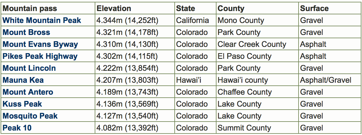
Colorado 14,120 Mount Evans
Colorado 14,115 Pikes Peak
Colorado 12,183 Trail Ridge Road Rocky Mtn NP (US 34)
Connecticut 1,555 Bald Mountain (CT 272)
Delaware 448 Ebright Azimuth
Florida 340 Lakewood
Georgia 4,388 Brasstown Bald gate (GA Alt 180)
Georgia 3,100 Neels Gap (US 19)
Hawaii 11,120 Mauna Loa Observatory
Hawaii 6,670 Humuula Saddle on Saddle Road (HI 200)
Idaho 9,261 Mount Harrison
Idaho 8,701 Galena Summit on ID 75
Illinois 1,142 1 mi. S of Scales Mound on CR 67
Indiana 1,253 Elliot Road by Hoosier Hill
Iowa 1,654 2 miles south of Bigelow, Minn. (IA 60)
Kansas 3,920 at state line by Kanorado (old US 24)
Kentucky 4,040 FAA site on Black Mountain
Kentucky 3,700 at VA state line (KY 160)
Louisiana 456 Old Athens
Maine 2,280 1 mile north of Appalachian Tr (ME 17)
Maryland 3,080 near Conneway Hill (US 50)
Massachusetts 3,465 Mount Greylock
Massachusetts 3,170 Mt Greylock turnoff on Rockwell Rd
Michigan 1,790 3/4 mile SE of Watersmeet Park (US 2)
Minnesota 2,040 ~4 miles south of Isabella (MN 1)
Mississippi 680 US 72 at jct. with road to Benton LO
Missouri 1,730 next to the Webster coHP (Road P)
Montana 10,200 Beartooth Hwy (US 212) at WY state line
Nebraska 5,105 Bushnell Exit (I-80)
Nevada 10,161 Wheeler Peak trailhead GBNP
Nevada 8,911 Mount Rose Summit on NV 431
New Hampshire 4,400 Mount Washington Auto Road
New Hampshire 2,860 Kancamagus Pass (NH 112)
New Jersey 1,803 High Point
New Jersey 1,513 turnoff to HP State Park from NJ 23
New Mexico 10,600 NM 532 at Sandia Crest
New Mexico 10,507 Brazos summit
New York 4,560 Whiteface Mtn Mem Hwy on 431
New York 2,680 at Winnisook Lake on CR 47
North Carolina 6,600 Mount Mitchell
North Carolina 6,160 Richland Balsam on Blue Ridge Parkaway
North Dakota 3,220 1.5 miles NW of Rhame (US 12)
Ohio 1,540 Hi Point Career Center
Ohio 1,530 2 mi. E of Bellefontaine (OH 540)
Oklahoma 4,846 state line west of Mexhoma
Oregon 7,877 viewpoint-east Crater Lake rim
Oregon 7,664 east side Crater Lake NP on Rim Drive
Pennsylvania 3,160 0.2 mi. E of Baughman Spring on 2004
Rhode Island 800 Jerimoth Hill on Hartford Pike
South Carolina 3,520 F Van Clayton Mem Hwy to Sassafras Mtn
South Carolina 3,160 at village of Caesars Head (US 276)
South Dakota 6,680 O'Neil Pass on US 85
Tennessee 5,723 Collins Gap GSMNP on Clingmans Dome Rd
Tennessee 5,000 Newfound Gap on US 441
Texas 6,791 McDonald Observatory (Mt Locke)
Texas 6,135 Beef Pasture Gap on TX 118
Utah 10,715 just SW of Bald Mountain Pass on UT 150
Vermont 3,840 Mount Equinox
Vermont 2,356 Appalachian Gap (VT 17)
Virginia 4,880 Grayson Highlands SP at Haw Orchard Mtn
Virginia 4,440 Elk Garden (VA 600)
Washington 6,400 Sunrise Ranger Station MRNP
Washington 5,575 Sherman Pass on WA 20
West Virginia 4,840 Snowshoe Ski Area
Wisconsin 1,930 Sugarbush Hill spur off Bradley Lake Rd
Wisconsin 1,810 north of Timms Hill (WI 86)
Wyoming 10,947 Beartooth Pass on Beartooth Hwy (US 212)
State / Elevation (ft) Highest point
Alabama 2,405 Cheaha Mountain
Alabama 2,100 at turnoff to Cheaha Mountain (AL 281)
Alaska 3,322 Eureka Summit on Glenn Hwy (AK 1)
Arizona 9,560 Arizona Snow Bowl
Arizona 9,370 ~4 mi. S of Hannagan Meadow (US 191)
Arkansas 2,681 Polk coHP
Arkansas 2,600 1.5 mi. W of Polk coHP, Skyline Dr.
California 10,320 Rock Creek Road from Toms Place
California 9,945 Tioga Pass on CA 120
Colorado 14,120 Mount Evans
Colorado 14,115 Pikes Peak
Colorado 12,183 Trail Ridge Road Rocky Mtn NP (US 34)
Connecticut 1,555 Bald Mountain (CT 272)
Delaware 448 Ebright Azimuth
Florida 340 Lakewood
Georgia 4,388 Brasstown Bald gate (GA Alt 180)
Georgia 3,100 Neels Gap (US 19)
Hawaii 11,120 Mauna Loa Observatory
Hawaii 6,670 Humuula Saddle on Saddle Road (HI 200)
Idaho 9,261 Mount Harrison
Idaho 8,701 Galena Summit on ID 75
Illinois 1,142 1 mi. S of Scales Mound on CR 67
Indiana 1,253 Elliot Road by Hoosier Hill
Iowa 1,654 2 miles south of Bigelow, Minn. (IA 60)
Kansas 3,920 at state line by Kanorado (old US 24)
Kentucky 4,040 FAA site on Black Mountain
Kentucky 3,700 at VA state line (KY 160)
Louisiana 456 Old Athens
Maine 2,280 1 mile north of Appalachian Tr (ME 17)
Maryland 3,080 near Conneway Hill (US 50)
Massachusetts 3,465 Mount Greylock
Massachusetts 3,170 Mt Greylock turnoff on Rockwell Rd
Michigan 1,790 3/4 mile SE of Watersmeet Park (US 2)
Minnesota 2,040 ~4 miles south of Isabella (MN 1)
Mississippi 680 US 72 at jct. with road to Benton LO
Missouri 1,730 next to the Webster coHP (Road P)
Montana 10,200 Beartooth Hwy (US 212) at WY state line
Nebraska 5,105 Bushnell Exit (I-80)
Nevada 10,161 Wheeler Peak trailhead GBNP
Nevada 8,911 Mount Rose Summit on NV 431
New Hampshire 4,400 Mount Washington Auto Road
New Hampshire 2,860 Kancamagus Pass (NH 112)
New Jersey 1,803 High Point
New Jersey 1,513 turnoff to HP State Park from NJ 23
New Mexico 10,600 NM 532 at Sandia Crest
New Mexico 10,507 Brazos summit
New York 4,560 Whiteface Mtn Mem Hwy on 431
New York 2,680 at Winnisook Lake on CR 47
North Carolina 6,600 Mount Mitchell
North Carolina 6,160 Richland Balsam on Blue Ridge Parkaway
North Dakota 3,220 1.5 miles NW of Rhame (US 12)
Ohio 1,540 Hi Point Career Center
Ohio 1,530 2 mi. E of Bellefontaine (OH 540)
Oklahoma 4,846 state line west of Mexhoma
Oregon 7,877 viewpoint-east Crater Lake rim
Oregon 7,664 east side Crater Lake NP on Rim Drive
Pennsylvania 3,160 0.2 mi. E of Baughman Spring on 2004
Rhode Island 800 Jerimoth Hill on Hartford Pike
South Carolina 3,520 F Van Clayton Mem Hwy to Sassafras Mtn
South Carolina 3,160 at village of Caesars Head (US 276)
South Dakota 6,680 O'Neil Pass on US 85
Tennessee 5,723 Collins Gap GSMNP on Clingmans Dome Rd
Tennessee 5,000 Newfound Gap on US 441
Texas 6,791 McDonald Observatory (Mt Locke)
Texas 6,135 Beef Pasture Gap on TX 118
Utah 10,715 just SW of Bald Mountain Pass on UT 150
Vermont 3,840 Mount Equinox
Vermont 2,356 Appalachian Gap (VT 17)
Virginia 4,880 Grayson Highlands SP at Haw Orchard Mtn
Virginia 4,440 Elk Garden (VA 600)
Washington 6,400 Sunrise Ranger Station MRNP
Washington 5,575 Sherman Pass on WA 20
West Virginia 4,840 Snowshoe Ski Area
Wisconsin 1,930 Sugarbush Hill spur off Bradley Lake Rd
Wisconsin 1,810 north of Timms Hill (WI 86)
Wyoming 10,947 Beartooth Pass on Beartooth Hwy (US 212)
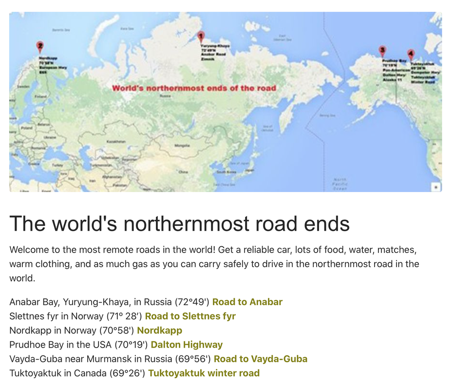
MOST DANGEROUS / SCENIC, US:
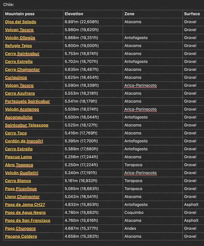
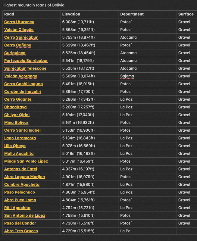
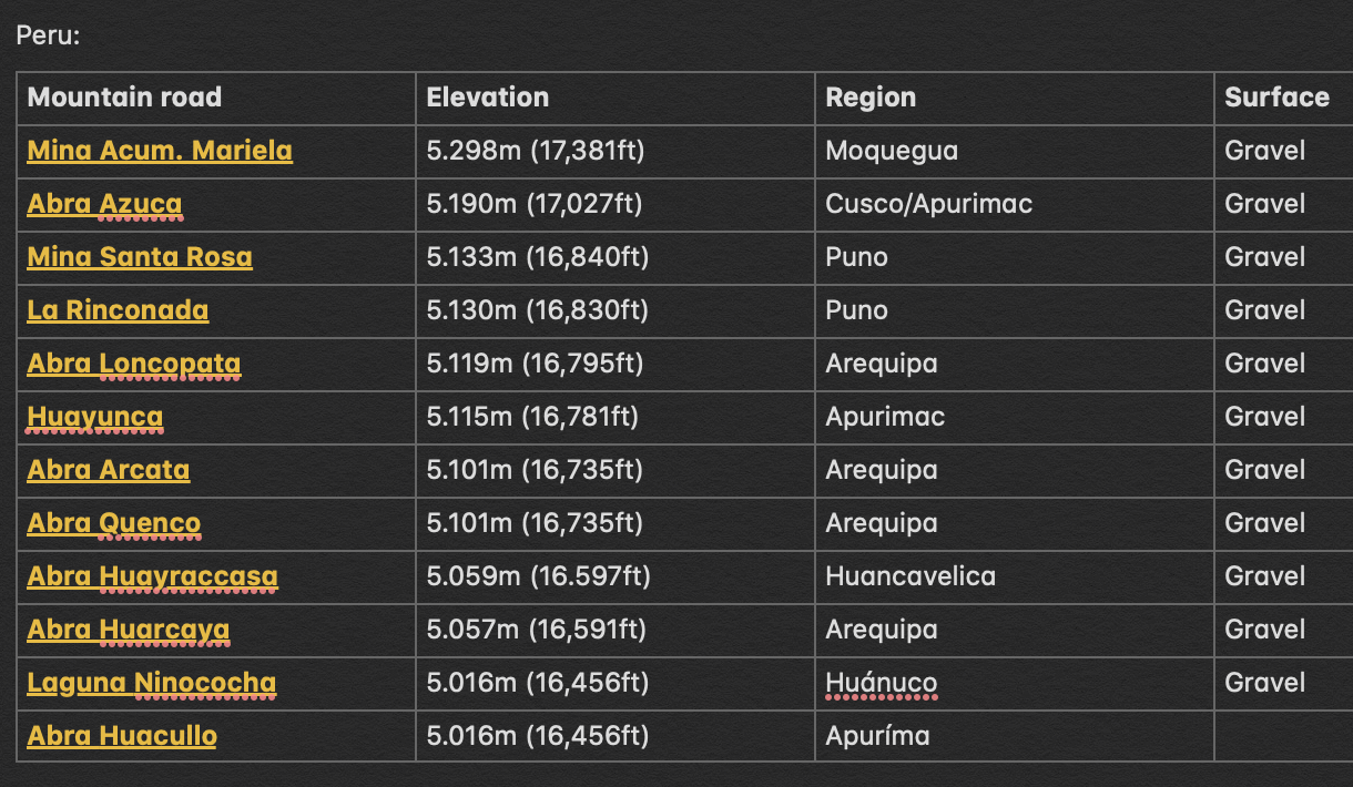
PAN-AMERICAN HIGHWAY and SOUTH AMERICA's HIGH ALTITUDE ROADS
Pan-American Highway
Trans-Andean Highway
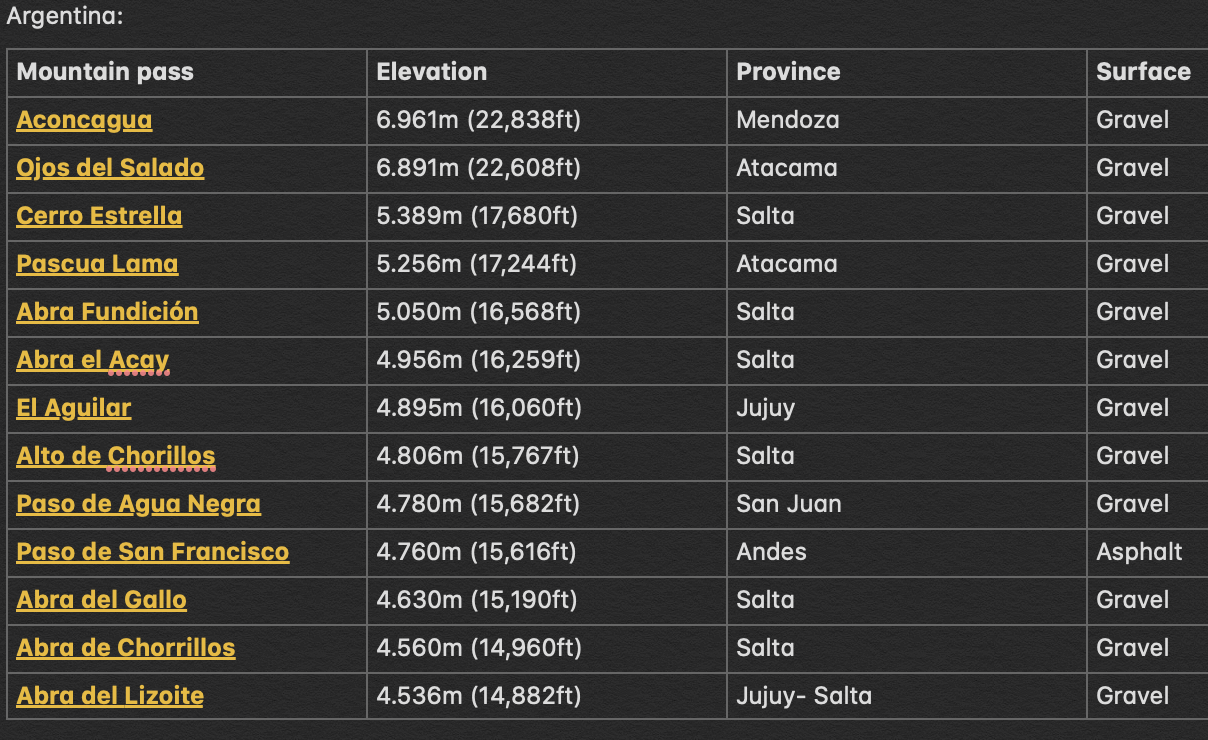
Also, going South to North, highest roads/passes by country:
Pan-American Highway
Trans-Andean Highway
Also, going South to North, highest roads/passes by country:
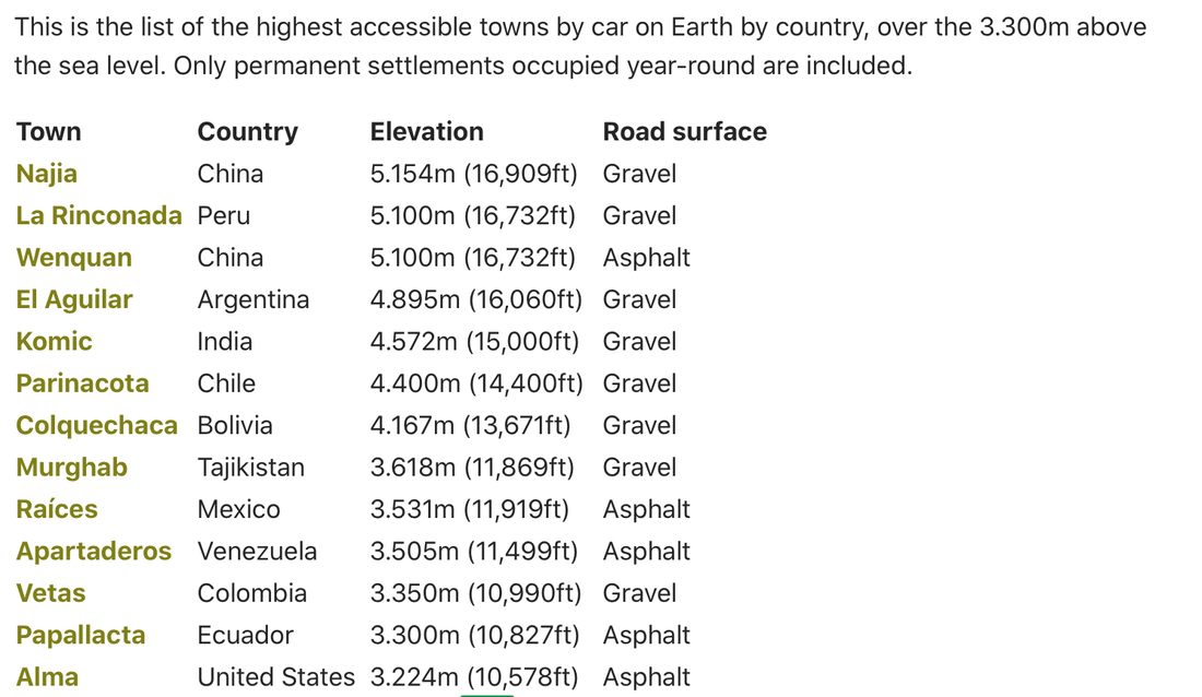
Highest permanently inhabited locations in the world: